

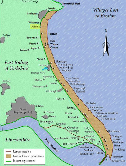
Live Science has a very interesting article about an attempt to find the remains of the town of Ravenser Odd or Ravenspurn which was a medieval settlement at the tip of Spurn Point at the mouth of the Humber.
It appears to have come into being about 1235 but after a period of considerable growth began to decline about 1300. This may have been due in part to environmental factors and possibly also to the development of King Edward I’s new port of Kingston upon Hull. Other ports such as Hedon and Patrington were still flourishing as witnessed by their wonderful churches and Ravenspurn may well have been in an especially vulnerable position. A major inundation by the sea as recorded by the chronicle of the nearby abbey at Mesux in 1362 probably marked the end of the town. It seems to have had a reputation for smuggling and may well have been a maritime equivalent of places like the seventeenth century Port Royal in Jamaica or Gold Rush towns in North America and Australia. A ‘get rich quick’ place with s disreputable image, but big enough and important enough to send MPs to early Parliaments.
By 1399 when Henry Bolingbroke, and certainly by 1471 when King Edward IV landed there, it was just a windswept spit reaching out into the Humber. Apart from a lighthouse being built so it has remained, with the whole Point gradually shifting and curving into the mouth of the Humber.
Until the seventeenth century the Humber below Kingston upon Hull simply widened out to reach the North Sea between Spurn Point and Donna Nook. In the later seventeenth century Sunk Island was reclaimed from the waters of the Humber and by the beginning of the nineteenth century joined to the rest of the Eadt Riding, thus creating the distinctive’dog -leg’ profile of the estuary.
Most maps in history books do not indicate the coastline as it was at the appropriate time between Flamborough Head and Beach Head, yet the coast has receded significantly along much of that littoral in historic rather than just geological time. In other places, such as the mouth of the Humber, parts of the Suffolk coast, around Thanet and at Dungeness the land mass has been reclaimed or simply deposited by the tide.
The Live Science article can be read at Yorkshire's 'Atlantis' may finally be revealed
It will be interesting to see if something of the town can be recovered and understood. I have seen maps reconstructing the plan of the other most famous victim of the North Sea, Dunwich on the coast of Suffolk based upon archaeological surveys as well as early maps in that particular case as more of the town survived into relatively modern times.
No comments:
Post a Comment